

Each season several national meteorological services and scientific agencies forecast how many tropical cyclones, tropical storms, and typhoons will form during a season and/or how many tropical cyclones will affect a particular country.
City University of Hong Kong
Since the 2000 Pacific typhoon season, the Guy Carpenter Asia-Pacific Climate Impact Centre (GCACIC), of the City University of Hong Kong (CityUHK), have issued forecasts of activity for each upcoming typhoon season. Forecasts on the number of tropical cyclones, tropical storms and typhoons there would be during 2010 in the Western Pacific were released in April and June. For the first time this year the GCACIC issued forecasts in May and July, which predicted how many tropical cyclones would make landfall in South China, and pass within 100 km (60 mi) of either the Korean Peninsula or Japan during 2010.
In its April 2010 forecast; GCACIC predicted that 28 tropical cyclones, 24 tropical storms, and 16 typhoons would form in the western north Pacific this year. However in its June forecast the GCACIC reported that they now only expected 27 tropical cyclones, 23 tropical storms, and 15 typhoons, to form during the season. As a result of their predictions the GCACIC also predicted that tropical cyclone activity would be below average for the 12 year in a row. In May the GCACIC forecasted that between May and December, six tropical cyclones would make landfall on Southern China and another six tropical cyclones would make landfall on or pass within 100 km (60 mi) of either the Korean Peninsula or Japan. In July the GCACIC forecast that between July and December three tropical cyclones would make landfall on Southern China, whilst four tropical cyclones would make landfall on or pass within 100 km (60 mi) of either the Korean Peninsula or Japan.
Tropical Storm Risk Consortium
Since the 2000 Pacific typhoon season, the Tropical Storm Risk Consortium (TSR) of the University College of London have issued forecasts of activity for each upcoming typhoon season. Forecasts on the number of tropical storms, typhoons and intense typhoons there would be during 2010 in the Western Pacific were released in March, May, July and August.[nb 1] In its March forecast TSR predicted that the season would see activity close to the average with 26 tropical storms, 16 typhoons and 7 intense typhoons developing during the season. In its May forecast, whilst lowering their initial prediction for the amount of tropical storms and typhoons, TSR continued to predict that the season would see activity close to the average, with 24 tropical storms, 15 typhoons and 9 intense typhoons developing during the season In its July forecast TSR significantly lowered their forecast and reported that they now expected activity to be 20% below average, with 23 tropical storms 14 typhoons and 7 intense typhoons developing during the season. In its August forecast TSR predicted that activity would be 25% - 30% below average with 23 tropical storms, 13 typhoons and 6 intense typhoons developing during the season. TSR also predicted that if their august forecast came true then the season would be in the lowest 25% of seasons.
National meteorological service predictions
The Philippine Atmospheric, Geophysical and Astronomical Services Administration (PAGASA) reported on January 7 that they were expecting a total of 19 tropical cyclones to pass through the Philippine area of responsibility during 2010. On March 23 the Hong Kong Observatory (HKO), predicted that less than 6 tropical cyclones would affect Hong Kong during the season.As a result of being under the influence of a weakening El Niño, the HKO also predicted that the chances of a tropical cyclone affecting Hong Kong before June was not high. After Vietnam was hit by Tropical Depression 01W in January, the Vietnamese National Center for Hydro Meteorological forecasts predicted in May that 6-7 tropical cyclones would affect Vietnam during 2010. Whilst the Thai Meteorological Department predicted that one or two tropical cyclones would pass through Vietnam and affect Thailand between August and November.On June 30, the Central Weather Bureau of Taiwan predicted that the 2010 season would be below its normal climatic average of 26.6, and predicted that 20-23 tropical storms, would occur over the Western Pacific during 2010. The Central Weather Bureau also predicted that between two and four tropical storms would affect Taiwan during 2010.After the slow start to the season, PAGASA released a new prediction on July 5 stating that they now only expected 13-15 tropical cyclones to pass through the region.
Season summary
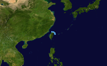
The first tropical cyclone of the season; Tropical Depression 01W formed on January 18, about 300 km to the northeast of Brunei. During the next 2 days the depression moved quickly and made landfall on Vietnam and dissipated over Cambodia during January 20. The depression caused 3 deaths and caused $243,000 USD in damage to Vietnam. After 01W had dissipated the Western Pacific became dormant until Tropical Storm Omais formed about 325 km (200 mi) to the southeast of Chuuk Island on March 22. During the next couple of days Omais impacted the Micronesian islands of Woleai, Fais Ulithi and Yap, before moving into the Philippine area of responsibility and being named as Agaton by PAGASA. However Omais (Agaton) dissipated on March 26 before it could affect the Philippines. After Omais dissipated there were 2 non developing tropical depressions only monitored by the JMA in April and June before on July 11 the first typhoon of the season: Conson formed.
Storms
Tropical Depression 01W
Tropical depression (JMA)
Tropical depression (SSHS)

Duration January 18 – January 20
Intensity 45 km/h (30 mph) (10-min), 1006 hPa (mbar)
Early on January 18 the JMA reported that a tropical depression had formed within the northeast monsoon about 320 km (200 mi) to the north-west of Bandar Seri Begawan in Brunei. The depression's low level circulation center was partially exposed and located within an area of moderate to strong vertical wind shear.However over the next 12 hours, whilst the depression moved towards Vietnam, the low level circulation center rapidly consolidated and became well defined after the vertical wind shear around the system relaxed.As a result of this the JTWC initiated advisories on the depression, designating it as Tropical Depression 01W. During the next day, the depression weakened with the low level circulation center becoming partially exposed, as it moved over an area of cold sea surface temperatures. As a result of this the JTWC issued their final advisory on the system later that day. The depression then made landfall on Vietnam near Gò Công early on January 20 before the JMA then issued their final advisory later that day as the system dissipated over Cambodia.
Within Vietnam strong waves caused by the tropical depression caused 3 people to die, while rowing their coracles to find shelter. 68 boats were also destroyed as the depressions wind speed changed direction.
Tropical Storm Omais (Agaton)
Tropical storm (JMA)
Tropical storm (SSHS)
Duration March 22 – March 26
Intensity 65 km/h (40 mph) (10-min), 998 hPa (mbar)
On March 18, the JTWC reported that an area of deep atmospheric convection had persisted about 325 km (200 mi) to the southeast of Chuuk Island in southern Micronesia.[25] At this stage the poorly organised deep convection was located over a low level circulation center and was in an area of low wind shear. Over the next couple of days both the low level circulation center and the deep convection gradually became better organized, prompting the issuance of a tropical cyclone formation alert late on March 20. During the next day convection continued to build over the low level circulation center, which became well defined whilst moving around the subtropical ridge. The JTWC then initiated advisories on the system later that day, designating it as Tropical Depression 02W, although the JMA did not designate the system as a tropical depression until early on March 22. During March 22 further development of the system was hampered by an anticyclone to the east of the system that caused moderate to strong wind shear.Early of the next day, JTWC upgraded the depression into a tropical storm, and on 24 March JMA upgraded it to Tropical Storm Omais, the first of the season. Late on March 25, the JTWC downgraded Omais to tropical depression strength. Tropical Depression Omais re-gained tropical storm status late on March 26 as it was becoming extratropical.
Tropical Depression
Tropical depression (JMA)

Duration April 26 – April 27
Intensity Winds unknown, 1008 hPa (mbar)
On April 24, an area of low pressure had been formed about 140 km (85 mi) to the west of Palau Island .[33] On the next day, the disturbance start to move westward. On the same time, the disturbance suddenly strengthened and its LLCC began to consolidate as well as significant banding all over the system and located over moderate vertical wind shear. Early of April 26, the disturbance rapidly strengthen again and was starting to be enhanced by a Tropical Upper Tropospheric Trough (TUTT) cell to the northeast of the system, whilst the JMA upgraded it into a tropical depression. Later that day, the depression made landfall over Davao City and Surigao del Sur boundary and crossed central Mindanao. Early on April 27, JMA downgraded the depression into an area of low pressure while it was located in vicinity of Sulu Island. In the next couple of days the low pressure start to move northwest towards South China Sea. On the same time, the low pressure crossed Palawan Island on the afternoon of April 29. On the next day, the low pressure was located about 415 km (260 mi) from Manila. In the evening of that day, the low pressure was last seen in vicinity of the Zambales area and was absorbed by a frontal system.
The depression brought torrential rains to Mindanao causing slight floods in the area. No casualties were reported. When the depression reached Sulu, it was downgraded to a low pressure system. However, it still caused heavy rains in Eastern Visayas, Southern Luzon and Manila.
Tropical Depression
Tropical depression (JMA)

Duration June 3 – June 6
Intensity Winds unknown, 1002 hPa (mbar)
Early on June 2, the JMA reported that a low pressure area had formed in the vicinity of Hainan island. During the next 36 hours the low pressure area moved to the east before late on June 3, the JMA reported that the system had intensified into a tropical depression whilst located about 600 km (370 miles) to the northwest of Manila, Philippines.
On June 6, the JMA stopped monitoring the depression.
Typhoon Conson (Basyang)
Typhoon Conson (2010)
Typhoon (JMA)
Category 1 typhoon (SSHS)

Duration July 11 – July 18
Intensity 130 km/h (80 mph) (10-min), 970 hPa (mbar)
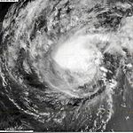
Typhoon Conson, developed into a tropical depression early on July 11 before rapidly developing into the second tropical storm of the season and named as Conson during the next day. During that afternoon Conson, kept intensifying before the JMA reported that Conson had reached its initial ten-minute peak sustained wind speeds of 110 km/h (75 mph), which made it a severe tropical Storm on the JMA's scale. Later that day, the JTWC reported that Conson had intensified into a typhoon before reporting early on July 13 the next day that it had reached its initial one-minute peak sustained wind speeds of 110 km/h (75 mph) which made it a Category 1 typhoon on the Saffir Simpson Hurricane Scale. During July 13, Conson started to started to weaken as it interacted with the Philippines before it made landfall near General Nakar, Quezon. Whilst over the Philippines Conson moved towards the west and passed over Manila before moving into the South China Sea early on July 14. During that day Conson weakened further under the influence of high vertical wind shear before during the next day the vertical wind shear weakened slightly. As a result Conson intensified over the South China Sea and became a typhoon early on July 16, with the JMA reporting ten-minute peak sustained wind speeds of 130 km/h (80 mph), whilst the JTWC reported peak one minute wind speeds of 150 km/h (90 mph) later that day as it passed closed to Hainan Island. After passing close to Hainan island, Conson moved into an area with high levels of vertical wind shear and as a result it rapidly weakened into a tropical storm, before making landfall in Vietnam during July 17.
On the morning of July 13, DEPED suspended all elementary and preschool classes in Metro Manila and some other provinces. All flights were canceled due to heavy rains and strong winds brought by Conson. Severe flooding was also reported in Bicol region. In addition, Conson sank three fishing vessels in the province of Catanduanes, Philippines. JTWC's 6:00 bulletin indicated that Conson would be passing through Metro Manila at about 2 or 3 in the morning the following day, which it did.
By late evening, Conson began its westerly path towards the direction of Metro Manila. Heavy rains and strong winds battered the Metropolis throughout the night. By 11 pm, PAGASA raised storm warning in the Metro to Signal number two. At 12:42 am, Meralco cut off power supplies to Metro Manila and nearby areas amidst various reports that billboards fell through power lines around the area; as much as 12 million people in Metro Manila alone still have their power services restored by the afternoon. At least twenty-six people were killed, and 38 were left missing in the Philippines as a result of the storm. The province of Laguna was placed under a state of calamity as a result of the storm. An estimated P47 million worth of agricultural products were damaged in the province. On July 16, the National Disaster Coordinating Council has revised the death toll to 38. The power outage also rendered the PAGASA website offline.
Typhoon Chanthu (Caloy)
Typhoon Chanthu (2010)
Typhoon (JMA)
Category 1 typhoon (SSHS)

Duration July 17 – July 23
Intensity 130 km/h (80 mph) (10-min), 970 hPa (mbar)
Early on July 17, the JMA reported that a tropical depression had developed about 220 km (135 mi) to the northeast of Manila, Philippines. Later that day the JTWC reported that the depression had a small low level circulation center with deep convection flaring to the northeast of the center. However as the low level circulation center was located close to land and was not very organized, the JTWC declared that there was a poor chance of it becoming a significant tropical cyclone within 48 hours. However during that day, the depression rapidly consolidated with an anticyclone helping to develop the low level circulation center. As a result early the next day the JTWC issued a tropical cyclone formation alert on the depression, however they thought that further development might be hindered as it was located close to land. Whilst it moved along the southern edge of the subtropical ridge, the Depression made landfall on Aurora province at 0600 UTC, before the JTWC initiated advisories later that morning, as the low level circulation center had consolidated and poleward outflow into the tropical upper tropospheric trough had improved. Late on July 19, PAGASA issued their last advisory on Tropical Storm Caloy as it had moved out of their Area of Responsibility.
Wikinews has related news: Typhoon kills two in southern China
Following the system's development, PAGASA stated that rainfall from system could trigger landslides and flooding in Aurora, the Bicol Region, and Quezon. Throughout Aurora, heavy rains triggered flash flooding which destroyed at least one home and stranded hundreds of residents. The Paltic barangay, within Dingalan, became inaccessible to rescuers after the local river topped its banks and washed out nearby slopes.
When it rain bands passed over Hong Kong, heavy rains brought about serious floodings across the territory. The Black Rainstorm Signal was issued. Two people were drowned and found dead, and two are still missing.
Tropical Depression
Tropical depression (JMA)

Duration July 18 – July 20
Intensity 55 km/h (35 mph) (10-min), 1004 hPa (mbar)
Early on July 17, an area of low pressure formed about 415 km (260 mi), southeast of Okinawa, Japan. The next day, the low pressure started to move slowly northwest. On the evening of July 18 at 12:00 (UTC), JMA reported that the low pressure intensified into a minor tropical depression. On the next day, the depression continued to move northwest until on early of July 20, the depression was absorbed by frontal system. On that same day, the Japan Meteorological Agency issued their final advisory on the depression.
Tropical Depression
Tropical depression (JMA)
Duration July 24 – July 25
Intensity Winds unknown, 1008 hPa (mbar)
Early on July 24, the JMA reported that a tropical depression had formed about 50 km (30 mi) to the east of Taipei, Taiwan. The depression was in an area of moderate vertical windshear and had a broad low level circulation. Later that day the depression made landfall in Yilan County before the JMA stopped monitoring the depression as it dissipated near the coast of Fujian province.
Tropical Depression
Tropical depression (JMA)

Duration July 26 – July 28
Intensity 55 km/h (35 mph) (10-min), 1002 hPa (mbar)
Late on July 26 the JMA reported that a tropical depression had formed off the coast of Zhejiang province, about 400 km (250 mi) to the south of Shanghai China. During the next day the depression remained offshore and moved towards the north passing about 120 km (75 mi) to the southeast of Shanghai before early on July 28 weakening into an area of low pressure. During that day the area of low pressure kept moving north before dissipating later that day as it affected South Korea.
Tropical Storm Domeng
Tropical storm (PAGASA)

Duration August 3 – August 5
Intensity 65 km/h (40 mph) (10-min), 997 hPa (mbar)
Late on August 2, PAGASA reported that a low pressure area had formed within the Intertropical convergence zone about 570 km to the northeast of Virac, Catanduanes.[49] Early the next day PAGASA reported that the low pressure area had intensified into a tropical depression and named it as Domeng.[50] During that day Domeng interacted with another low pressure area which was located to the north of the system, before merging with it early on August 4. After Domeng, had merged with the low pressure area PAGASA reported that Domeng had intensified into a tropical storm and reached its 10-minute peak sustained windspeeds of 65 km/h (40 mph). Later that day PAGASA reported that Domeng had weakened into a tropical depression, before reporting early the next day that after it had passed through the Babuyan Islands, Domeng had weakened into an area of low pressure.
In Luzon, heavy rain produced by the storm led to a few landslides, prompting road closures. Offshore, three people drowned after their boat capsized amidst rough seas produced by Domeng.
Severe Tropical Storm Dianmu (Ester)
Severe tropical storm (JMA)
Tropical storm (SSHS)

Duration August 6 – August 12
Intensity 100 km/h (65 mph) (10-min), 980 hPa (mbar)
Early on August 6, the JTWC reported that a tropical disturbance formed within the monsoon gyre about 800 km (500 mi) southeast of Taipei, Taiwan. Later that day PAGASA reported that the disturbance had developed into a tropical depression and named it as Ester, before the JTWC issued a tropical cyclone formation alert early the next day. During that day the JMA started to monitor the depression before the JTWC designated it as Tropical Depression 05W. The depression was then upgraded into a tropical storm by the JMA and named "Dianmu", the mother of lightning in Chinese folklore, with the JTWC following suit soon after. Early the next day, the JMA further upgraded the tropical storm into a severe tropical storm. After moving northward for several days, it turned northeastward and struck southern South Korea. Dianmu weakened as it crossed the Korean peninsula and emerged into the Sea of Japan
Heavy rains produced by the storm resulted in one fatality after a cargo ship sank amidst rough seas produced by the storm. In South Korea, at least three people were killed by Dianmu in flood-related incidents. This marked the first time in nine years that a rain-related fatality took place in the capital city of Seoul. More than 3,000 homes were destroyed in eastern China after heavy rains from the outer bands of Dianmu struck the region. Later reports stated that five people had been confirmed to have died as a result of Dianmu in South Korea. The storm made landfall on Japan; exiting the country within five hours. Heavy rains were reported through out the islands.
Nearly a week after the two ships sank off the coast of the Philippines, 31 crew members remain missing and are presumed dead after numerous coast guard rescue attempts. Damage from the storm on Jeju Island amounted to 5 billion won ($4.2 million USD).
Tropical Storm Mindulle

Tropical Storm Mindulle (2010)
Tropical storm (JMA)
Tropical storm (SSHS)
Duration August 21 – August 25
Intensity 85 km/h (50 mph) (10-min), 990 hPa (mbar)
Early on August 17, an area of low pressure formed about 415 km (260 mi), northeast of Tuguegarao City, Cagayan. The next day the disturbance started to move west. However, on the evening of August 18, as it crossed Babuyan Islands, the disturbance's low level center (LLC) weakened due to land interaction and high vertical wind shear. It regenerated on August 20 when it was located about 280 km (175 miles), to the west of Dagupan City, Pangasinan. Early on the next day, the disturbance started to move west and located in warm water temperatures and favorable conditions with moderate vertical wind shear. At the same time, the LCC of the disturbance became partially exposed due to a Tropical Upper Tropospheric Trough (TUTT) that was developing off Luzon at that time. On the afternoon of that day, Japan Meteorological Agency (JMA) upgraded the system into a tropical depression.The next day, they further upgraded the depression into a tropical storm and named it "Mindulle". At the same time, the JTWC reported that Tropical Depression 06W has intensified into a tropical storm.
As the storm neared Vietnam, thousands of fishermen were urged to return to port. According to Vietnamese officials, contact was lost with 10 vessels on August 24 and the 137 fishermen on the ships were listed as missing.[58] Widespread heavy rainfall, peaking at 297 mm (11.7 in), led to significant flooding and agricultural losses across Vietnam.
Tropical Depression
Tropical depression (JMA)

Duration August 26 – August 29
Intensity 55 km/h (35 mph) (10-min), 1004 hPa (mbar)
This section requires expansion.
Severe Tropical Storm Lionrock (Florita)
Severe tropical storm (JMA)
Tropical storm (SSHS)
Duration August 27 – September 4
Intensity 95 km/h (60 mph) (10-min), 985 hPa (mbar)
Early on August 25, an area of low pressure formed about 415 km (260 mi), to the east of Cagayan, Philippines. The low pressure is located in an area of low vertical wind shear and a favorable environment. On the same time, a Tropical upper tropospheric trough (TUTT) was located in the east of the system. On the next day, the disturbance started to move west and later crossed the island of Luzon but on the next day, the circulation became slightly disorganized due to dry air. Later that afternoon, the Japan Meteorological Agency (JMA) upgraded the disturbance to a tropical depression and the Joint Typhoon Warning Centre (JTWC) issued a Tropical Cyclone Formation Alert (TCFA) which was later upgraded to a tropical depression. On August 28, the JMA upgraded the system to a Tropical Storm and was named "Lionrock". On the next couple of days, Lionrock remains almost stationary in South China Sea. On August 31, Lionrock start to move northeast slowly due to interaction with tropical storm Namtheun. Early of september 1, Lionrock made a Fujiwhara effect with Namtheun, whilst Lionrock maintained it's strength while Namtheun was absorbed. Lionrock made landfall on the east coast of Guangdong Province, China, just north of the city of Shantou. It then started to dissipate and weaken into a tropical storm and moved over Guangzhou, Guangdong's capital. Lionrock soon lost it's intensity as it went over Guangdong, and on the September 3, the storm had turned into a low pressure area.
Typhoon Kompasu (Glenda)
Typhoon (JMA)
Category 3 typhoon (SSHS)

Duration August 28 – September 3
Intensity 150 km/h (90 mph) (10-min), 960 hPa (mbar)
Typhoon Kompasu (2010)
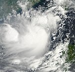
On early August 27, an area of low pressure formed about 305 km (200 mi) to the east of Yap Island. At that time, the system was disorganized due to high vertical wind shear. On the next day, the system started to move northwest and crossed Guam island. On the evening of that day, the system was located about 370 km (250 mi) northwest of Guam. At that time, the system experienced low vertical windshear and was located in a favorable environment. A Tropical Upper Tropospheric Trough (TUTT) was located to the east of the system. At that time, the Japan Meteorological Agency (JMA) upgraded the system into a tropical depression. Midday of August 29, the Joint Typhoon Warning Centre (JTWC) issued a Tropical Cyclone Formation Alert (TCFA) on the system as the Low Level Circulation Centre had become organized. On the morning of that same day, the JTWC announced that the system had quickly developed into a tropical storm and assigned the designation "08W". Intensification continued, then by midday of August 30, the JMA reported that the depression had intensified into a tropical storm and assigned it the international designation "Kompasu". In addition, PAGASA also announced that the low pressure in the northeast of Batanes had formed and assigned it a local name, "Glenda". After six hours, the JMA reported that Kompasu had intensified rapidly into a severe tropical storm. At the same time, the JTWC also upgraded Kompasu into a category 1 typhoon. On the next day, Kompasu crossed the island of Kadena and rapidly intensified into a category 2 typhoon equivalent. On September 1, Kompasu was upgraded by JTWC as a category 3 typhoon equivalent, becoming the strongest typhoon of the season.
The storm later weakened to a category one typhoon in the Yellow Sea, before veering northeast and making landfall on Ganghwa Island, northwest of Incheon and Seoul, killing at least four people.Kompasu was the strongest tropical storm to hit the Seoul metropolitan area in 15 years. Kompasu weakened to a tropical storm over the Sea of Japan on September 2.
Tropical Storm Namtheun
Tropical storm (JMA)
Tropical storm (SSHS)

Duration August 28 – August 31
Intensity 85 km/h (50 mph) (10-min), 994 hPa (mbar)
On August 27, an extensive cloud formed in the waters east of Taiwan. On August 28, it developed into a low pressure. At 18:00, near Yaeyama Islands, the Japan Meteorological Agency upgraded the low pressure into a tropical depression. There were two tropical cyclones developing on both sides of 09W (namely Lionrock and Kompasu), and Typhoon Kompasu had a relatively stronger intensity, causing 09W moved southwest to Taiwan Strait. This tropical depression lingered in the east of Taiwan for over a day. On August 30, it caused heavy rain in northern Taiwan. Taiwan's Central Weather Bureau could only issue a tropical depression warning since it had not strengthened to a tropical storm. At 20:00, 09W suddenly intensified into a tropical storm, and was named Namtheun. However, due to the development of another stronger tropical storm Lionrock at South China Sea, the increase of intensity of Namtheun was difficult. In the evening hours of August 31, Namtheun weakened into a tropical depression north of Taiwan Strait, then continued to move south to southwest, and skirted the southern coast of Fujian province. It continued to weaken, and finally transformed into a low pressure along the coast of Huian, Guangdong. Early of September 1, Lionrock made a Fujiwhara effect with Namtheun, whilst Lionrock maintained it's strength while Namtheun was absorbed.
Tropical Depression
Tropical depression (JMA)
Duration August 29 – August 31
Intensity Winds unknown, 1008 hPa (mbar)
Late on August 28, the Central Pacific Hurricane Center reported that an area of low pressure system associated with a tropical disturbance had developed about 1,000 mi (1,600 km) to the southwest of Honolulu in Hawaii. Isolated thunderstorms were developing in association with the small low-level circulation. During the next day the disturbance moved towards the west and moved into the western Pacific where the JMA immediately designated it as a tropical depression.
The depression was expected to bring inclement weather to Majauro and nearby atolls, although the system significantly weakened before reaching the area.
Severe Tropical Storm Malou (Henry)
Severe tropical storm (JMA)
Tropical storm (SSHS)
Duration September 1 – September 10
Intensity 95 km/h (60 mph) (10-min), 985 hPa (mbar)
Tropical Storm Malou (2010)
Malou started out as a tropical depression wardering around the Western Pacific. It moved into the Philippine Area of Responsibility and was given the name Henry. It remained for a depression for two days before it strengthened in to a tropical storm and was given the name Malou. Malou drifted over the Ryukyu Islands and became a severe tropical storm. After passing through Ryukyu Islands, Malou was expected to make a landfall on Jeju Island; instead, it turned northeast and landed on Tsushima Island as a tropical storm on September 7. It then moved along the coast of Honshū and made another landfall near Tsuruga, Fukui Prefecture, Japan on September 8. After the second landfall, Malou weakened into a tropical depression over Shizuoka Prefecture. Nevertheless, it lingered over Kantō region and caused heavy rain in Greater Tokyo Area until it transitioned into a polar low on September 10
Tropical Storm Meranti
Tropical storm (JMA)
Category 1 typhoon (SSHS)

Duration September 6 – September 11
Intensity 85 km/h (50 mph) (10-min), 990 hPa (mbar)
Early on September 6, the JMA reported that a tropical depression had formed about 330 km (205 mi) to the southeast of Taipei, Taiwan. Later that day the JTWC started to monitor the system and reported that the depression, had an unorganized low level circulation center that had convection flaring over it and was located in a favorable environment of decreasing vertical windshear and high sea surface temperatures. During the next day as the depression moved towards Taiwan the system became better organized with a tropical cyclone formation alert issued later that day. In the morning of September 9, JMA upgraded the cyclone into a tropical storm, and it was named Meranti. After Meranti was upgraded into a tropical storm, it continued to move northward into Taiwan Strait. In the early hours of September 10, Meranti made a landfall at Shishi City, Quanzhou, Fujian Province, China. It continued to move north toward inland Fujian. In the evening of September 10, the JMA downgraded Meranti into a tropical depression.
Typhoon Fanapi (Inday)
Typhoon (JMA)
Category 3 typhoon (SSHS)

Duration September 14 – Still active
Intensity 175 km/h (110 mph) (10-min), 935 hPa (mbar)
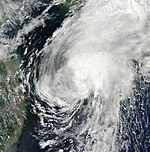
Early on September 14, the JMA reported that a tropical depression had formed east of Taiwan. The Joint Typhoon Warning Center soon designated the depression as 12W with PAGASA naming it Inday shortly thereafter. Later on the same day, the tropical depression was upgraded to a tropical storm and was officially given the name Fanapi by the JMA. On September 16, the storm further intensified into a severe tropical storm. That same day, the JMA further upgraded it into a typhoon. Fanapi turned west and intensified into a category 1 typhoon that night. On the following day, the storm further intensified into a category 2 typhoon. New and modified warnings were issued on the Taiwan coast. On September 18, the storm further intensified to a Category 3 typhoon and movedstraight into Taiwan. It made landfall in Hualien County at 8:40 a.m.(Local time) on September 19.
Tropical Depression 13W
Tropical depression (SSHS)
Duration September 19 – Still Active
Intensity 55 km/h (35 mph) (1-min), 1004 hPa (mbar)
Storm Names
Within the Northwestern Pacific Ocean, there are two separate agencies who assign names to tropical cyclones which often results in a cyclone having two names. The Japan Meteorological Agency names tropical cyclones should they be judged to have 10-minute sustained windspeeds of 65 km/h, (40 mph), to the north of the equator between the 180° and 100°E. Whilst the Philippine Atmospheric, Geophysical and Astronomical Services Administration assigns names to tropical cyclones which move into or form as a tropical depression in their area of responsibility located between 135°E and 115°E and between 5°E-25°E even if the cyclone has had a name assigned to it by the Japan Meteorological Agency. Names in bold are storms that are currently active, and unused names are marked in gray.
International names
Tropical Cyclones are named from the following lists by the Regional Specialized Meteorological Centre in Tokyo, Japan, once they reach tropical storm strength. Names are contributed by members of the ESCAP/WMO Typhoon Committee. Each of the 14 nations or territories submitted 10 names, which are used in alphabetical order, by the English name of the country.The next 24 names on the naming list are listed here. Lionrock and Fanapi were used for the first time, having replaced Tingting and Rananim in
|
|
|
|
Philippines
The Philippine Atmospheric, Geophysical and Astronomical Services Administration uses its own naming scheme for tropical cyclones in their area of responsibility. PAGASA assigns names to tropical depressions that form within their area of responsibility and any tropical cyclone that might move into their area of responsibility. Should the list of names for a given year prove to be insufficient, names are taken from an auxiliary list, the first 10 of which are published each year before the season starts.
|
|
|
|
|
Note: The names Milenyo and Reming were retired by PAGASA and are expected to be replaced.
Season effects
This table lists all the storms that developed in the western Pacific Ocean to the west of the International Date Line during the 2010 season. It includes their intensity, duration, name, landfalls, deaths, and damages. All damage figures are in 2010 USD. Damages and deaths from a storm include when the storm was a precursor wave or extratropical low.
(source:wikipedia)
No comments:
Post a Comment