

The city is located on the north bank of the Potomac River and is bordered by the states of Virginia to the southwest and Maryland to the other sides. The District has a resident population of 599,657; because of commuters from the surrounding suburbs, its population rises to over one million during the workweek. The Washington Metropolitan Area, of which the District is a part, has a population of 5.4 million, the eighth-largest metropolitan area in the country.
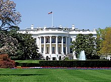
The centers of all three branches of the federal government of the United States are located in the District, as are many of the nation's monuments and museums. Washington, D.C. hosts 174 foreign embassies as well as the headquarters of the World Bank, the International Monetary Fund (IMF), the Organization of American States (OAS), the Inter-American Development Bank, and the Pan American Health Organization (PAHO). The headquarters of other institutions such as trade unions, lobbying groups, and professional associations are also located in the District.
Washington, D.C., is governed by a mayor and a 13-member city council. However, the United States Congress has supreme authority over the city and may overturn local laws. Residents of the District therefore have less self-governance than residents of the states. The District has a non-voting, at-large Congressional delegate, but no senators. D.C. residents could not vote in presidential elections until the ratification of the Twenty-third Amendment to the United States Constitution in 1961.
Washington, D.C. History,
History of Washington, D.C.,
An Algonquian-speaking people known as the Nacotchtank inhabited the area of present-day Washington around the Anacostia River when the first Europeans arrived in the 17th century; however, Native American people had largely relocated from the area by the early 18th century. The Province of Maryland chartered Georgetown on the north bank of the Potomac River in 1751. The busy port town would be included within the new federal territory established nearly 40 years later. The City of Alexandria, Virginia, founded in 1749, was also originally included within the District.
James Madison expounded the need for a federal district on January 23, 1788, in his "Federalist No. 43", arguing that the national capital needed to be distinct from the states in order to provide for its own maintenance and safety.
.
An attack on the Congress at Philadelphia by a mob of angry soldiers, known as the Pennsylvania Mutiny of 1783, had emphasized the need for the government to see to its own security.Therefore, the authority to establish a federal capital was provided in Article One, Section Eight, of the United States Constitution, which permits a "District (not exceeding ten miles square) as may, by cession of particular states, and the acceptance of Congress, become the seat of the government of the United States". The Constitution does not, however, specify a location for the new capital. In what later became known as the Compromise of 1790, Madison, Alexander Hamilton, and Thomas Jefferson came to an agreement that the federal government would assume war debt carried by the states, on the condition that the new national capital would be located in the Southern United States.

The United States Capitol after the burning of Washington, D.C. in the War of 1812.
On July 16, 1790, the Residence Act provided for a new permanent capital to be located on the Potomac River, the exact area to be selected by President Washington. As permitted by the U.S. Constitution, the initial shape of the federal district was a square, measuring 10 miles (16 km) on each side, totaling 100 square miles (260 km2). During 1791–92, Andrew Ellicott and several assistants, including Benjamin Banneker, surveyed the border of the District with both Maryland and Virginia, placing boundary stones at every mile point. Many of the stones are still standing. A new "federal city" was then constructed on the north bank of the Potomac, to the east of the established settlement at Georgetown. On September 9, 1791, the federal city was named in honor of George Washington, and the district was named the Territory of Columbia, Columbia being a poetic name for the United States in use at that time. Congress held its first session in Washington on November 17, 1800.
The Organic Act of 1801 officially organized the District of Columbia and placed the entire federal territory, including the cities of Washington, Georgetown, and Alexandria, under the exclusive control of Congress. Further, the unincorporated territory within the District was organized into two counties: the County of Washington to the east of the Potomac and the County of Alexandria to the west. Following this Act, citizens located in the District were no longer considered residents of Maryland or Virginia, thus ending their representation in Congress.

Ford's Theatre in the 19th century, site of the 1865 assassination of President Lincoln
On August 24–25, 1814, in a raid known as the Burning of Washington, British forces invaded the capital during the War of 1812, following the sacking and burning of York (modern-day Toronto). The Capitol, Treasury, and White House were burned and gutted during the attack. Most government buildings were quickly repaired, but the Capitol, which was at the time largely under construction, was not completed in its current form until 1868.
Since 1800, the District's residents have protested their lack of voting representation in Congress. To correct this, various proposals have been offered to return the land ceded to form the District back to Maryland and Virginia. This process is known as retrocession. However, such efforts failed to earn enough support until the 1830s when the District's southern county of Alexandria went into economic decline partly due to neglect by Congress. Alexandria had been a major market in the American slave trade, and rumors circulated that abolitionists in Congress were attempting to end slavery in the District; such an action would have further depressed Alexandria's slavery-based economy. Unhappy with Congressional authority over Alexandria, in 1840 residents began to petition for the retrocession of the District's southern territory back to Virginia. The state legislature complied in February 1846, partly because the return of Alexandria provided two additional pro-slavery delegates to the Virginia General Assembly. On July 9, 1846, Congress agreed to return all the District's territory south of the Potomac River to the Commonwealth of Virginia.
Confirming the fears of pro-slavery Alexandrians, the Compromise of 1850 outlawed the slave trade in the District, though not slavery itself. By 1860, approximately 80% of the city's African American residents were free blacks. The outbreak of the American Civil War in 1861 led to notable growth in the District's population due to the expansion of the federal government and a large influx of freed slaves. In 1862, President Abraham Lincoln signed the Compensated Emancipation Act, which ended slavery in the District of Columbia and freed about 3,100 enslaved persons, nine months prior to the Emancipation Proclamation. By 1870, the District's population had grown to nearly 132,000. Despite the city's growth, Washington still had dirt roads and lacked basic sanitation; the situation was so bad that some members of Congress proposed moving the capital elsewhere.

Crowds surrounding the Reflecting Pool during the 1963 March on Washington
With the Organic Act of 1871, Congress created a new government for the entire federal territory. This Act effectively combined the City of Washington, Georgetown, and Washington County into a single municipality officially named the District of Columbia. Even though the City of Washington legally ceased to exist after 1871, the name continued in use and the whole city became commonly known as Washington, D.C. In the same Organic Act, Congress also appointed a Board of Public Works charged with modernizing the city. In 1873, President Grant appointed the board's most influential member, Alexander Shepherd, to the new post of governor. That year, Shepherd spent $20 million on public works ($357 million in 2007), which modernized Washington but also bankrupted the city. In 1874, Congress abolished Shepherd's office in favor of direct rule. Additional projects to renovate the city were not executed until the McMillan Plan in 1901.
The District's population remained relatively stable until the Great Depression in the 1930s when President Franklin D. Roosevelt's New Deal legislation expanded the bureaucracy in Washington. World War II further increased government activity, adding to the number of federal employees in the capital; by 1950, the District's population had reached a peak of 802,178 residents. The Twenty-third Amendment to the United States Constitution was ratified in 1961, granting the District three votes in the Electoral College for the election of President and Vice President, but still no voting representation in Congress.
After the assassination of civil rights leader Dr. Martin Luther King, Jr., on April 4, 1968, riots broke out in the District, primarily in the U Street, 14th Street, 7th Street, and H Street corridors, centers of black residential and commercial areas. The riots raged for three days until over 13,000 federal and national guard troops managed to quell the violence. Many stores and other buildings were burned; rebuilding was not complete until the late 1990s.
In 1973, Congress enacted the District of Columbia Home Rule Act, providing for an elected mayor and city council for the District. In 1975, Walter Washington became the first elected and first black mayor of the District. However, during the later 1980s and 1990s, city administrations were criticized for mismanagement and waste. In 1995, Congress created the District of Columbia Financial Control Board to oversee all municipal spending and rehabilitate the city government.The District regained control over its finances in September 2001 and the oversight board's operations were suspended.
On September 11, 2001, terrorists hijacked American Airlines Flight 77 and deliberately crashed the plane into the Pentagon in nearby Arlington, Virginia. United Airlines Flight 93, believed to be destined for Washington, D.C., crashed in Pennsylvania when passengers tried to recover control of the plane from hijackers.
Geography
Main article: Geography of Washington, D.C.

The Chesapeake and Ohio Canal passes through the Georgetown neighborhood.
The District has a total area of 68.3 square miles (177 km2), of which 61.4 square miles (159 km2) is land and 6.9 square miles (18 km2) (10.16%) is water. The District is no longer 100 square miles (260 km2) due to the retrocession of the southern portion of the District back to the Commonwealth of Virginia in 1846. The District's current area consists only of territory ceded by the state of Maryland. Washington is therefore surrounded by the states of Maryland to the southeast, northeast, and northwest and Virginia to the southwest. The District has three major natural flowing streams: the Potomac River and its tributaries the Anacostia River and Rock Creek. Tiber Creek, a watercourse that once passed through the National Mall, was fully enclosed underground during the 1870s.
Contrary to the urban legend, Washington was not built on reclaimed swampland. While wetlands did cover areas along the two rivers and other natural streams, the majority of the District's territory consisted of farmland and tree-covered hills. The highest natural point in the District of Columbia is Point Reno, located in Fort Reno Park in the Tenleytown neighborhood, at 409 feet (125 m) above sea level. The lowest point is sea level at the Potomac River. The geographic center of Washington is located near the intersection of 4th and L Streets NW.
Approximately 19.4% of Washington, D.C. is parkland, which ties New York City for largest percentage of parkland among high-density U.S. cities. The high percentage of park area in the District contributes to urban tree canopy coverage of 35%, as of 2010. The U.S. National Park Service manages most of the natural habitat in Washington, D.C., including Rock Creek Park, the Chesapeake and Ohio Canal National Historical Park, the National Mall, Theodore Roosevelt Island, the Constitution Gardens, Meridian Hill Park, and Anacostia Park. The only significant area of natural habitat not managed by the National Park Service is the U.S. National Arboretum, which is operated by the U.S. Department of Agriculture.The Great Falls of the Potomac River are located upstream (northwest) of Washington. During the 19th century, the Chesapeake and Ohio Canal, which starts in Georgetown, was used to allow barge traffic to bypass the falls.
Washington, D.C. Climate,
Maryland and Washington, D.C. hurricanes (1980–present) and List of District of Columbia tornadoes
Washington is located in the humid subtropical climate zone (Köppen: Cfa), exhibiting four distinct seasons. Its climate is typical of Mid-Atlantic U.S. areas removed from bodies of water. The District is located in plant hardiness zone 8a near downtown, and zone 7b elsewhere in the city, indicating a temperate climate. Spring and fall are warm, while winter is cool with annual snowfall averaging 14.7 inches (37 cm). Winter temperatures average around 38 °F (3.3 °C) from mid-December to mid-February.Blizzards affect Washington on average once every four to six years. The most violent storms are called "nor'easters", which typically feature high winds, heavy rains, and occasional snow. These storms often affect large sections of the U.S. East Coast.
Summers are hot and humid with a July daily average of 79.2 °F (26.2 °C) and average daily relative humidity around 66%, which can cause medium to moderate personal discomfort.The combination of heat and humidity in the summer brings very frequent thunderstorms, some of which occasionally produce tornadoes in the area. While hurricanes (or their remnants) occasionally track through the area in late summer and early fall, they have often weakened by the time they reach Washington, partly due to the city's inland location. Flooding of the Potomac River, however, caused by a combination of high tide, storm surge, and runoff, has been known to cause extensive property damage in Georgetown.
The highest recorded temperature was 106 °F (41 °C) on July 20, 1930, and August 6, 1918, while the lowest recorded temperature was −15 °F (−26 °C) on February 11, 1899, during the Great Blizzard of 1899. Over the year, the city averages 37 days hotter than 90 °F (32.2 °C) and 64 nights at or below freezing.
| ]Climate data for Washington, DC (Reagan National | |||||||||||||
|---|---|---|---|---|---|---|---|---|---|---|---|---|---|
| Month | Jan | Feb | Mar | Apr | May | Jun | Jul | Aug | Sep | Oct | Nov | Dec | Year |
| Average high °F (°C) | 42.5 (5.83) | 46.5 (8.06) | 55.7 (13.17) | 66.3 (19.06) | 75.4 (24.11) | 83.9 (28.83) | 88.3 (31.28) | 86.3 (30.17) | 79.3 (26.28) | 68.0 (20) | 57.3 (14.06) | 47.0 (8.33) | 66.4 (19.11) |
| Average low °F (°C) | 27.3 (-2.61) | 29.7 (-1.28) | 37.3 (2.94) | 45.9 (7.72) | 55.8 (13.22) | 65.0 (18.33) | 70.1 (21.17) | 68.6 (20.33) | 61.8 (16.56) | 49.6 (9.78) | 40.0 (4.44) | 32.0 (0) | 48.6 (9.22) |
| Precipitation inches (mm) | 3.21 (81.5) | 2.63 (66.8) | 3.60 (91.4) | 2.77 (70.4) | 3.82 (97) | 3.13 (79.5) | 3.66 (93) | 3.44 (87.4) | 3.79 (96.3) | 3.22 (81.8) | 3.03 (77) | 3.05 (77.5) | 39.35 (999.5) |
| Snowfall inches (cm) | 5.9 (15) | 5.1 (13) | 1.6 (4.1) | 0 (0) | 0 (0) | 0 (0) | 0 (0) | 0 (0) | 0 (0) | 0 (0) | 0.7 (1.8) | 1.4 (3.6) | 14.7 (37.3) |
| Avg. precipitation days (≥ 0.01 in) | 10.5 | 9.3 | 10.6 | 9.6 | 11.2 | 10.2 | 10.4 | 8.6 | 8.1 | 7.8 | 8.5 | 9.5 | 114.3 |
| Avg. snowy days (≥ 0.1 in) | 3.1 | 2.2 | 1.1 | 0.1 | 0 | 0 | 0 | 0 | 0 | 0 | 0.5 | 1.1 | 8.1 |
| Sunshine hours | 145.7 | 152.6 | 204.6 | 228.0 | 260.4 | 282.0 | 279.0 | 263.5 | 225.0 | 204.6 | 150.0 | 133.3 | 2,528.7 |
| Source #1: The Weather Channel , NOAA | |||||||||||||
| Source #2: HKO | |||||||||||||
Washington, D.C. Cityscape,
Streets and highways of Washington, D.C., List of neighborhoods of the District of Columbia by ward, and List of tallest buildings in Washington, D.C.
.jpg)
L'Enfant's plan for Washington, D.C., as revised by Andrew Ellicott (1792)
Washington, D.C. is a planned city. The design for the City of Washington was largely the work of Pierre (Peter) Charles L’Enfant, a French-born architect, engineer, and city planner who first arrived in the colonies as a military engineer with Major General Lafayette during the American Revolutionary War. In 1791, President Washington commissioned L'Enfant to plan the layout of the new capital city. At L’Enfant’s request, Thomas Jefferson provided plans of cities such as Amsterdam, Paris, Frankfurt, Karlsruhe and Milan, which he had brought back from Europe in 1788. The plan for Washington was modeled in the Baroque style and incorporated avenues radiating out from rectangles, providing room for open space and landscaping. L'Enfant's design also envisioned a garden-lined "grand avenue" approximately 1 mile (1.6 km) in length and 400 feet (120 m) wide in the area that is now the National Mall.
In March 1792, President Washington dismissed L'Enfant due to his insistence on micromanaging the city's planning, which had resulted in conflicts with the three commissioners appointed by Washington to supervise the capital's construction. Andrew Ellicott, who had worked with L'Enfant surveying the city, was then commissioned to complete the plans. Though Ellicott made revisions to the original plans, including changes to some street patterns, L'Enfant is still credited with the overall design of the city. The City of Washington was bounded by what is now Florida Avenue to the north, Rock Creek to the west, and the Anacostia River to the east.
By the start of the 20th century, L'Enfant's vision of a capital with open parks and grand national monuments had become marred by slums and randomly placed buildings, including a railroad station on the National Mall. In 1900, Congress formed a joint committee, headed by Senator James McMillan, charged with beautifying Washington's ceremonial core. What became known as the McMillan Plan was finalized in 1901. It included the re-landscaping of the Capitol grounds and the Mall, constructing new Federal buildings and monuments, clearing slums, and establishing a new citywide park system. Architects recruited by the committee kept much of the city's original layout, and their work is thought to be largely in keeping with L'Enfant's intended design.

Washington, D.C. is divided into four quadrants.
After the construction of the twelve-story Cairo Apartment Building in 1894, Congress passed the Heights of Buildings Act, which limited building heights in the city. The Act was amended in 1910 to restrict building height to the width of the adjacent street plus 20 feet (6.1 m). Despite popular belief, no law has ever limited buildings to the height of the United States Capitol or the Washington Monument. Today the skyline remains low and sprawling, in keeping with Thomas Jefferson's wishes to make Washington an "American Paris" with "low and convenient" buildings on "light and airy" streets. As a result, the Washington Monument remains the District's tallest structure. However, Washington's height restriction has been assailed as a primary reason why the city has limited affordable housing and traffic problems as a result of urban sprawl. Not subject to the District's height restriction, a number of taller buildings close to downtown have been constructed across the Potomac River in Rosslyn, Virginia.
The District is divided into four quadrants of unequal area: Northwest (NW), Northeast (NE), Southeast (SE), and Southwest (SW). The axes bounding the quadrants radiate from the U.S. Capitol building. All road names include the quadrant abbreviation to indicate their location. In most of the city, the streets are set out in a grid pattern with east–west streets named with letters (e.g., C Street SW) and north–south streets with numbers (e.g., 4th Street NW). Some Washington streets are particularly noteworthy, such as Pennsylvania Avenue, which connects the White House with the U.S. Capitol, and K Street, which houses the offices of many lobbying groups.[66] Washington hosts 174 foreign embassies, 59 of which are located on a section of Massachusetts Avenue informally known as Embassy Row,.
Washington, D.C. Architecture,

The White House ranked second on the AIA's "List of America's Favorite Architecture" in 2007.
The architecture of Washington varies greatly. Six of the top 10 buildings in the American Institute of Architects' 2007 ranking of "America's Favorite Architecture" are located in the District of Columbia: the White House; the Washington National Cathedral; the Thomas Jefferson Memorial; the United States Capitol; the Lincoln Memorial; and the Vietnam Veterans Memorial. The neoclassical, Georgian, gothic, and modern architectural styles are all reflected among those six structures and many other prominent edifices in Washington. Notable exceptions include buildings constructed in the French Second Empire style such as the Old Executive Office Building.
Outside downtown Washington, architectural styles are even more varied. Historic buildings are designed primarily in the Queen Anne, Châteauesque, Richardsonian Romanesque, Georgian revival, Beaux-Arts, and a variety of Victorian styles. Rowhouses are especially prominent in areas developed after the Civil War and typically follow Federalist and late Victorian designs. Since Georgetown was established before the city of Washington, the neighborhood features the District's oldest architecture. Georgetown's Old Stone House was built in 1765, making it the oldest-standing original building in the city. The majority of current homes in the neighborhood, however, were not built until the 1870s and reflect late Victorian designs of the period. Founded in 1789, Georgetown University is more distinct from the neighborhood and features a mix of Romanesque and Gothic Revival architecture. The Ronald Reagan Building is the largest building in the District with a total area of approximately 3.1 million square feet (288,000 m2),.
Washington, D.C. Demographics,
Demographics of Washington, D.C.
| Historical Populations | ||
|---|---|---|
| Year | Population | Change |
| 1800 | 8,144 | – |
| 1810 | 15,471 | 90.0% |
| 1820 | 23,336 | 50.8% |
| 1830 | 30,261 | 29.7% |
| 1840 | 33,745 | 11.5% |
| 1850 | 51,687 | 53.2% |
| 1860 | 75,080 | 45.3% |
| 1870 | 131,700 | 75.4% |
| 1880 | 177,624 | 34.9% |
| 1890 | 230,392 | 29.7% |
| 1900 | 278,718 | 21.0% |
| 1910 | 331,069 | 18.8% |
| 1920 | 437,571 | 32.2% |
| 1930 | 486,869 | 11.3% |
| 1940 | 663,091 | 36.2% |
| 1950 | 802,178 | 21.0% |
| 1960 | 763,956 | −4.8% |
| 1970 | 756,510 | −1.0% |
| 1980 | 638,333 | −15.6% |
| 1990 | 606,900 | −4.9% |
| 2000 | 572,059 | −5.7% |
| 2009 | 599,657 | 4.8% |
In 2009, the U.S. Census Bureau estimated the District's population at 599,657 residents, continuing a trend of population growth in the city since the 2000 Census, which recorded 572,059 residents. During the workweek, however, the number of commuters from the suburbs into the city swells the District's population by an estimated 71.8% in 2005, to a daytime population of over one million people. The Washington Metropolitan Area, which includes the surrounding counties in Maryland and Virginia, is the ninth-largest in the United States with more than five million residents. When combined with Baltimore and its suburbs, the Baltimore-Washington Metropolitan Area has a population exceeding eight million residents, the fourth-largest in the country.
According to the 2007 American Community Survey conducted by the U.S. Census Bureau, the population distribution of Washington, D.C. is 55.6% Black or African American, 36.3% White, 3.1% Asian, and 0.2% American Indian. Individuals from other races made up 4.8% of the District's population while individuals from two or more races made up 1.6%. In addition, Hispanics of any race made up 8.3% of the District's population. There were also an estimated 74,000 foreign immigrants living in Washington, D.C. in 2007. Major sources of immigration include individuals from El Salvador, Vietnam, and Ethiopia, with some concentration of Salvadorans in the Mount Pleasant neighborhood.
Unique among cities with a high percentage of African Americans, Washington has had a significant black population since the city's creation. This is partly a result of the manumission of slaves in the Upper South after the American Revolutionary War. The free black population in the region climbed from an estimated 1% before the war to 10% by 1810. In the District, black residents composed about 30% of the population between 1800 and 1940.
Washington's black population reached a peak of 70% of the city's residents by 1970. Since then, however, the District's black population has steadily declined due to many blacks leaving the city for the surrounding suburbs. Some older residents have returned South because of family ties and lower housing costs. At the same time, the city's white population has steadily increased, in part due to effects of gentrification in many of Washington's traditionally black neighborhoods. This is evident in a 7.3% decrease in the black population and a 17.8% increase in the white population since 2000.However, some blacks, particularly college graduates and young professionals, are moving from northern and Midwestern states in a New Great Migration. Washington, D.C. is a top destination for such blacks because of increased job opportunities.
The 2000 census revealed that an estimated 33,000 adults in the District of Columbia identify as gay, lesbian, or bisexual, about 8.1% of the city's adult population.Given the city's sizable LGBT population and liberal political climate, a same-sex marriage bill passed the Council of the District of Columbia and was signed by the mayor in December 2009. The District began issuing marriage licenses to same-sex couples in March 2010.
A report in the year 2007 found that about one-third of District residents are functionally illiterate, compared to a national rate of about one in five. This is attributed in part to immigrants who are not proficient in English. A 2005 study shows that 85.16% of Washington, D.C.'s residents age five and older speak only English at home and 8.78% speak Spanish. French is the third-most-spoken language at 1.35%. In contrast to the high rate of functional illiteracy, nearly 46% of D.C.'s residents have at least a four-year college degree. According to data from 2000, more than half of District residents were identified as Christian: 28% of residents are Roman Catholic, 9.1% are American Baptist, 6.8% are Southern Baptist, 1.3% are Eastern or Oriental Orthodox, and 13% are members of other Christian denominations. Residents who practice Islam make up 10.6% of the population, followers of Judaism compose 4.5%, and 26.8% of residents adhere to other faiths or do not practice a religion.
Washington, D.C. Crimes,
Crime in Washington, D.C.,
Metropolitan Police Department of the District of Columbia
During the violent crime wave of the early 1990s, Washington, D.C. was known as the murder capital of the United States and often rivaled New Orleans in the number of homicides. The number of murders peaked in 1991 at 479, but the level of violence declined drastically in the 1990s. By 2009, the annual murder count in the city had declined to 143, the lowest number since 1966. In total, violent crime declined nearly 47% between 1995 and 2007. Property crime, including thefts and robberies, declined by roughly 48% during the same period.
Like most large cities, crime is highest in areas associated with illegal drugs and gangs. The more affluent neighborhoods of Northwest Washington experience low levels of crime, but the incidence of crime generally increases as one goes further east. Once plagued with violent crime, many D.C. neighborhoods such as Columbia Heights and Logan Circle are becoming safe and vibrant areas due to overall trends of reduced crime in the District and also through the effects of gentrification. As a result, however, experts point to the city's changing demographics as a reason why crime in the District is being overshadowed by increased violence further east across the border in Prince George's County, Maryland.
On June 26, 2008, the Supreme Court of the United States held in District of Columbia v. Heller that the city's 1976 handgun ban violated the Second Amendment right to gun ownership. However, the ruling does not prohibit all forms of gun control; laws requiring firearm registration remain in place, as does the city's assault weapon ban,.
Washington, D.C. Economy,
Companies based in Washington, D.C.

Professors Gate at George Washington University, the largest private employer in the District
Washington has a growing, diversified economy with an increasing percentage of professional and business service jobs. The gross state product of the District in 2008 was $97.2 billion, which would rank it No. 35 compared to the 50 U.S. states. In 2008, the federal government accounted for about 27% of the jobs in Washington, D.C.This is thought to immunize Washington to national economic downturns because the federal government continues operations even during recessions.However, as of January 2007, federal employees in the Washington area comprised only 14% of the total U.S. government workforce. Many organizations such as law firms, independent contractors (both defense and civilian), non-profit organizations, lobbying firms, trade unions, industry trade groups, and professional associations have their headquarters in or near D.C. to be close to the federal government.
As of January 2010, the Washington Metropolitan Area had an unemployment rate of 6.9%; the second-lowest rate among the 49 largest metro areas in the nation. The District of Columbia itself had an unemployment rate of 12% during the same time period.
The District has growing industries not directly related to government, especially in the areas of education, finance, public policy, and scientific research. George Washington University, Georgetown University, Washington Hospital Center, Howard University, and Fannie Mae are the top five non-government-related employers in the city.There are five Fortune 1000 companies based in Washington, of which two are also Fortune 500 companies.
Washington became the leader in foreign real estate investment in 2009, ahead of both London and New York City, in a survey of the top 200 global development companies. In 2006, Expansion Magazine ranked D.C. among the top ten areas in the nation favorable to business expansion.Washington has the third-largest downtown in the United States in terms of commercial office space, directly behind New York City and Chicago. Despite the national economic crisis and housing price downturn, Washington ranked second on the Forbes list of the best long-term housing markets in the country.
Gentrification efforts are taking hold in Washington, D.C., notably in the neighborhoods of Logan Circle, Shaw, Columbia Heights, the U Street Corridor, and the 14th Street Corridor. Development was fostered in some neighborhoods by the late-1990s construction of the Green Line on Metrorail, Washington's subway system, which linked them to the downtown area. In March 2008, a new shopping mall in Columbia Heights became the first new major retail center in the District in 40 years. As in many cities, gentrification is revitalizing Washington's economy, but its benefits are unevenly distributed throughout the city and it is not directly helping poor people. In 2006, D.C. residents had a personal income per capita of $55,755, higher than any of the 50 U.S. states. However, 19% of residents were below the poverty level in 2005, higher than any state except Mississippi, which highlights the economic disparities in the city's population.
Washington, D.C. Culture,
Washington, D.C. Historic sites and museums,
National Historic Landmarks in Washington, D.C., National Register of Historic Places listings in Washington, D.C., and List of museums in Washington, D.C.

The National Museum of the American Indian opened in 2004.
The National Mall is a large, open park area in the center of the city. Located in the center of the Mall are the Washington Monument and the Jefferson Pier. Also located on the mall are the Lincoln Memorial, the National World War II Memorial at the east end of the Reflecting Pool, the Korean War Veterans Memorial, and the Vietnam Veterans Memorial. The National Archives houses thousands of documents important to American history including the Declaration of Independence, the United States Constitution, and the Bill of Rights.
Located directly south of the mall, the Tidal Basin features rows of Japanese cherry blossom trees that were presented as gifts from the nation of Japan. The Franklin Delano Roosevelt Memorial, Jefferson Memorial, and the District of Columbia War Memorial are located around the Tidal Basin.
The Smithsonian Institution is an educational foundation chartered by Congress in 1846 that maintains most of the nation's official museums and galleries in Washington, D.C. The U.S. government partially funds the Smithsonian, thus making its collections open to the public free of charge. The most visited of the Smithsonian museums in 2009 was the National Museum of Natural History located on the National Mall. Other Smithsonian Institution museums and galleries located on the mall are: the National Air and Space Museum; the National Museum of African Art; the National Museum of American History; the National Museum of the American Indian; the Sackler and Freer galleries, which both focus on Asian art and culture; the Hirshhorn Museum and Sculpture Garden; the Arts and Industries Building; the S. Dillon Ripley Center; and the Smithsonian Institution Building (also known as "The Castle"), which serves as the institution's headquarters.
The Smithsonian American Art Museum (formerly known as the National Museum of American Art) and the National Portrait Gallery are located in the same building, the Donald W. Reynolds Center, near Washington's Chinatown. The Reynolds Center is also known as the Old Patent Office Building.The Renwick Gallery is officially part of the Smithsonian American Art Museum but is located in a separate building near the White House. Other Smithsonian museums and galleries include: the Anacostia Community Museum in Southeast Washington; the National Postal Museum near Union Station; and the National Zoo in Woodley Park.
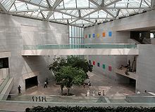
The East Building of the National Gallery of Art houses the modern art collection.
The National Gallery of Art is located on the National Mall near the Capitol, but is not a part of the Smithsonian Institution. It is instead wholly owned by the U.S. government; thus admission to the gallery is free. The gallery's West Building features the nation's collection of American and European art through the 19th century. The East Building, designed by architect I. M. Pei, features works of modern art. The Smithsonian American Art Museum and the National Portrait Gallery are often confused with the National Gallery of Art when they are in fact entirely separate institutions. The National Building Museum occupies the former Pension Building located near Judiciary Square, and was chartered by Congress as a private institution to host exhibits on architecture, urban planning, and design.
There are many private art museums in the District of Columbia, which house major collections and exhibits open to the public such as: the National Museum of Women in the Arts; the Corcoran Gallery of Art, the largest private museum in Washington; and The Phillips Collection in Dupont Circle, the first museum of modern art in the United States. Other private museums in Washington include the Newseum, the International Spy Museum, the National Geographic Society Museum, and the Marian Koshland Science Museum. The United States Holocaust Memorial Museum located near the National Mall maintains exhibits, documentation, and artifacts related to The Holocaust.,
Washington, D.C. Performing arts and music,
Theater in Washington, D.C. and Music of Washington, D.C.,
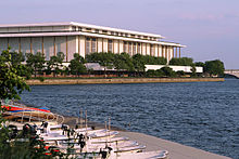
The John F. Kennedy Center for the Performing Arts is located along the Potomac River.
Washington, D.C. is a national center for the arts. The John F. Kennedy Center for the Performing Arts is home to the National Symphony Orchestra, the Washington National Opera, and the Washington Ballet. The Kennedy Center Honors are awarded each year to those in the performing arts who have contributed greatly to the cultural life of the United States. The President and First Lady typically attend the Honors ceremony, as the First Lady is the honorary chair of the Kennedy Center Board of Trustees. Washington also has a local independent theater tradition. Institutions such as Arena Stage, the Shakespeare Theatre Company, and the Studio Theatre feature classic works and new American plays.
The U Street Corridor in Northwest D.C., known as "Washington's Black Broadway", is home to institutions like Bohemian Caverns and the Lincoln Theatre, which hosted music legends such as Washington-native Duke Ellington, John Coltrane, and Miles Davis. Other jazz venues feature modern blues such as Madam's Organ in Adams Morgan and Blues Alley in Georgetown. D.C. has its own native music genre called go-go; a post-funk, percussion-driven flavor of R&B that blends live sets with relentless dance rhythms. The most accomplished practitioner was D.C. band leader Chuck Brown, who brought go-go to the brink of national recognition with his 1979 LP Bustin' Loose.
Washington is also an important center for indie culture and music in the United States. The label Dischord Records, formed by Ian MacKaye, was one of the most crucial independent labels in the genesis of 1980s punk and eventually indie rock in the 1990s. Washington's indie label history also includes TeenBeat, Simple Machines, and ESL Music among others. Modern alternative and indie music venues like The Black Cat and the 9:30 Club near U Street bring popular acts to smaller more-intimate venues,.
Washington, D.C. Media,
Media in Washington, D.C.,
Newspapers in Washington, D.C. and List of television shows set in Washington, D.C.

Washington's Newspaper Row on Pennsylvania Avenue in 1874
Washington, D.C. is a prominent center for national and international media. The Washington Post, founded in 1877, is the oldest and most-read local daily newspaper in Washington. It is probably most notable for its coverage of national and international politics as well as for exposing the Watergate scandal. "The Post", as it is popularly called, continues to print only three main editions; one each for the District, Maryland, and Virginia. Even without expanded national editions, the newspaper has the sixth-highest circulation of all news dailies in the country as of September 2008. USA Today, the nation's largest daily newspaper by circulation, is headquartered in nearby McLean, Virginia.
The Washington Post Company has a daily free commuter newspaper called the Express, which summarizes events, sports and entertainment, as well as the Spanish-language paper El Tiempo Latino. Local dailies The Washington Times and The Washington Examiner, the alternative Washington City Paper, and the weekly Washington Business Journal have substantial readership in the Washington area as well. A number of community and specialty papers focus on neighborhood and cultural issues including: the weekly Washington Blade and Metro Weekly, which focus on LGBT issues; the Washington Informer and The Washington Afro American, which highlight topics of interest to the black community; and neighborhood newspapers published by The Current Newspapers. The Hill and Roll Call newspapers focus exclusively on issues related to Congress and the federal government.
The Washington Metropolitan Area is the ninth-largest television media market in the U.S. with two million homes (approximately 2% of the U.S. population). Several media companies and cable television channels have their headquarters in the area, including: C-SPAN; Black Entertainment Television (BET); the National Geographic Channel; Smithsonian Networks; XM Satellite Radio; National Public Radio (NPR); Travel Channel (in Chevy Chase, Maryland); Discovery Communications (in Silver Spring, Maryland); and the Public Broadcasting Service (PBS) (in Arlington, Virginia). The headquarters of Voice of America, the U.S. government's international news service, is located near the Capitol in Southwest Washington. The D.C. area is also home to Radio One, the nation's largest African American television and radio conglomerate, founded by media mogul Cathy Hughes,.
Washington, D.C. Sports,
Sports in Washington, D.C.
U.S. cities with teams from four major sports

Verizon Center is home to the NHL's Capitals, the NBA's Wizards, the WNBA's Mystics, and the Georgetown Hoyas men's basketball team.
Washington, D.C. is home to five major professional men's teams. The Washington Wizards (National Basketball Association) and the Washington Capitals (National Hockey League) both play at the Verizon Center (right) in Chinatown. Nationals Park, which opened in Southeast D.C. in 2008, is home to the Washington Nationals (Major League Baseball). D.C. United (Major League Soccer) plays at RFK Stadium. The Washington Redskins (National Football League) play at nearby FedExField in Landover, Maryland.
The Washington area is also home to two women's professional sports teams. The Washington Mystics (WNBA) play at the Verizon Center, and the Washington Freedom (Women's Professional Soccer) play in nearby Germantown, Maryland and at RFK Stadium. Other professional and semi-professional teams in Washington include: the Washington Kastles (World TeamTennis); the Washington D.C. Slayers (American National Rugby League); the Baltimore Washington Eagles (USAFL); the D.C. Divas (Independent Women's Football League); the D.C. Explosion (NAFL); and the Potomac Athletic Club RFC (Rugby Super League).
Washington is one of only 13 cities in the United States with teams from all four major men's sports: football, basketball, baseball, and ice hockey. When soccer is included, Washington is one of only eight cities to have all five professional men's sports. Current D.C. teams have won a combined eight professional league championships: D.C. United has won four (the most in MLS history); the Washington Redskins has won three; and the Washington Wizards has won a single championship. The William H.G. FitzGerald Tennis Center in Rock Creek Park hosts the Legg Mason Tennis Classic. The Marine Corps Marathon and the National Marathon are both held annually in Washington. The D.C. area is home to one regional sports television network, Comcast SportsNet (CSN), based in Bethesda, Maryland,.
Washington, D.C. Government,
District of Columbia home rule and List of mayors of Washington, D.C.


The John A. Wilson Building houses the offices of the mayor and council of the District of Columbia.
Article One, Section Eight of the United States Constitution grants the U.S. Congress ultimate authority over Washington, D.C. The District of Columbia did not have an elected municipal government until the passage of the 1973 Home Rule Act. The Act devolved certain Congressional powers over the District to a local government administered by an elected mayor, currently Adrian Fenty, and the thirteen-member Council of the District of Columbia. However, Congress retains the right to review and overturn laws created by the city council and intervene in local affairs.
Each of the city's eight wards elects a single member of the council and five members, including the chairman, are elected at large.There are 37 Advisory Neighborhood Commissions (ANCs) elected by small neighborhood districts. ANCs traditionally wield a great deal of influence and the city government routinely takes their suggestions into careful consideration.

The United States Congress has ultimate authority over the District.
The mayor and council adopt a local budget, which must be approved by Congress. Local income, sales, and property taxes provide about 67% of the revenue to fund city government agencies and services. Like the 50 states, D.C. receives federal grants for assistance programs such as Medicare, accounting for approximately 26% of the city's total revenue. Congress also appropriates money to the District's government to help offset some of the city's security costs; these funds totaled $38 million in 2007, approximately 0.5% of the District's budget.
The Federal government operates the District's court system, and all federal law enforcement agencies, most visibly the U.S. Park Police, have jurisdiction in the city and help provide security as well. All local felony charges are prosecuted by the United States Attorney for the District of Columbia. U.S. Attorneys are appointed by the President and funded by the United States Department of Justice. In total, the federal government provided about 33% of the District's general revenue. On average, federal funds formed about 30% the states' general revenues in 2007.
The city's local government, particularly during the mayoralty of Marion Barry, was criticized for mismanagement and waste. Barry was elected mayor in 1978, serving three successive four-year terms. During his administration in 1989, The Washington Monthly magazine claimed that the District had "the worst city government in America". After being imprisoned for six months on misdemeanor drug charges in 1990, Barry did not run for reelection. In 1991, Sharon Pratt Kelly became the first black woman to lead a major U.S. city.
Barry was elected again in 1994, and by the next year the city had become nearly insolvent. Mayor Anthony Williams won election in 1998. His administration oversaw a period of greater prosperity, urban renewal, and budget surpluses.Since his election in 2006, Mayor Adrian Fenty has primarily focused on improving education. Shortly upon taking office, he won approval from the city council to directly manage and overhaul the city's under-performing public school system.
Washington, D.C. observes all federal holidays. The District also celebrates Emancipation Day on April 16, which commemorates the signing of the Compensated Emancipation Act by President Abraham Lincoln in 1862,.
Washington, D.C. Federal representation and taxation,
District of Columbia voting rights and Political party strength in Washington, D.C.

A sample Washington, D.C. license plate with "Taxation Without Representation" slogan
Citizens of the District of Columbia have no voting representation in Congress. They are represented in the House of Representatives by a non-voting delegate, Eleanor Holmes Norton (D-D.C. At-Large), who may sit on committees, participate in debate, and introduce legislation, but cannot vote on the House floor. D.C. has no representation in the United States Senate. Unlike residents of U.S. territories such as Puerto Rico or Guam, which also have non-voting delegates, citizens of the District of Columbia are subject to all U.S. federal taxes. In the financial year 2007, D.C. residents and businesses paid $20.4 billion in federal taxes; more than the taxes collected from 19 states and the highest federal taxes per capita.
A 2005 poll found that 78% of Americans did not know that residents of the District of Columbia have less representation in Congress than residents of the 50 states.Efforts to raise awareness about the issue have included campaigns by grassroots organizations as well as featuring the city's unofficial motto, "Taxation Without Representation", on D.C. vehicle license plates. There is evidence of nationwide approval for DC voting rights; various polls indicate that 61 to 82% of Americans believe that D.C. should have voting representation in Congress. Despite public support, attempts to grant the District voting representation, including the D.C. statehood movement and the proposed District of Columbia Voting Rights Amendment, have been unsuccessful.
Opponents of D.C. voting rights propose that the Founding Fathers never intended for District residents to have a vote in Congress since the Constitution makes clear that representation must come from the states. Those opposed to making D.C. a state claim that such a move would destroy the notion of a separate national capital and that statehood would unfairly grant Senate representation to a single city,.
Washington, D.C. Education and health care,
colleges and universities in Washington, D.C., List of parochial and private schools in Washington, D.C., and Healthcare in Washington, D.C.


Georgetown Visitation Preparatory School is an all-girls high school founded in 1799.
District of Columbia Public Schools (DCPS) operates the city's public school system, which consists of 167 schools and learning centers. The number of students in DCPS has steadily decreased since 1999. In the 2008–09 school year, 46,208 students were enrolled in the public school system. DCPS has one of the highest-cost yet lowest-performing school systems in the country, both in terms of infrastructure and student achievement. Mayor Adrian Fenty's new superintendent of DCPS, Chancellor Michelle Rhee, has made sweeping changes to the system by closing schools, replacing teachers, firing principals, and using private education firms to aid curriculum development.
Due to the problems with the D.C. public school system, enrollment in public charter schools has increased 13% each year since 2001. The District of Columbia Public Charter School Board monitors the 60 public charter schools in the city. As of fall 2008, D.C. charter schools had a total enrollment of 26,494. The District is also home to some of the nation's top private schools. In 2006, approximately 18,000 students were enrolled in the city's 83 private schools.

Founders Library at Howard University, a historically black university
Many notable private universities are located in Washington, including George Washington University (GW), Georgetown University (GU), American University (AU), the Catholic University of America (CUA), Howard University, Gallaudet University, and the Johns Hopkins University School of Advanced International Studies (SAIS). The Corcoran College of Art and Design provides specialized arts instruction and other higher-education institutions offer continuing, distance and adult education. The University of the District of Columbia (UDC) is a public university providing undergraduate and graduate education.
The District's 16 medical centers and hospitals make it a national center for patient care and medical research. The National Institutes of Health is located in nearby Bethesda, Maryland. Washington Hospital Center (WHC), the largest hospital campus in the District, is both the largest private and the largest non-profit hospital in the Washington area. Immediately adjacent to the WHC is the Children's National Medical Center. Children's is among the highest ranked pediatric hospitals in the country according to U.S. News & World Report. Many of the city's prominent universities, including George Washington, Georgetown, and Howard have medical schools and associated teaching hospitals. Walter Reed Army Medical Center is located in Northwest Washington and provides care for active-duty and retired personnel and their dependents.
A 2009 report found that at least 3% of District residents have HIV or AIDS, which the U.S. Centers for Disease Control and Prevention (CDC) characterizes as a "generalized and severe" epidemic. City officials claim that the rate of HIV infection is higher in D.C. than some countries in West Africa.
Transportation,
Transportation in Washington, D.C. and Streets and highways of Washington, D.C.
Metro Center is the transfer station for the Red, Orange, and Blue Metrorail lines.
The Washington Metropolitan Area is often cited as having some of the nation's worst traffic and congestion. In 2007, Washington commuters spent 60 hours a year in traffic delays, which tied for having the worst traffic in the country after Los Angeles. However, 37.7% of Washington commuters take public transportation to work, also the second-highest rate in the country.
The Washington Metropolitan Area Transit Authority (WMATA) operates the city's rapid transit system, Metrorail (most often referred to as the Metro), as well as Metrobus. The subway and bus systems serve both the District of Columbia and the immediate Maryland and Virginia suburbs. Metrorail opened on March 27, 1976 and presently consists of 86 stations and 106.3 miles (171.1 km) of track. With an average of one million trips each weekday in 2009, Metrorail is the nation's second-busiest rapid transit system in the country, after the New York City Subway.
WMATA expects an average one million Metrorail riders daily by 2030. The need to increase capacity has renewed plans to add 220 subway cars to the system and reroute trains to alleviate congestion at the busiest stations. Population growth in the region has revived efforts to construct two additional suburban Metro lines, as well as a new streetcar system to interconnect the city's neighborhoods. The DC Circulator bus system connects commercial and entrainment areas within central Washington.Metrorail, Metrobus and all local public bus systems in the metropolitan area accept SmarTrip, a reloadable transit pass.

Interior of terminals B and C at Reagan National Airport, the closest commercial airport to downtown Washington
Union Station is the second-busiest train station in the United States, after Penn Station in New York, and serves as the southern terminus of Amtrak's Northeast Corridor and Acela Express service. Maryland's MARC and Virginia's VRE commuter trains and the Metrorail Red Line also provide service into Union Station.[186] Intercity bus service is provided by Greyhound, Peter Pan, BoltBus, Megabus, and many other Chinatown bus lines.
Three major airports, one in Maryland and two in Virginia, serve Washington, D.C. Ronald Reagan Washington National Airport, located just across the Potomac River from downtown D.C. in Arlington County, Virginia, is the only Washington-area airport that has its own Metrorail station. Given its proximity to the city, Reagan National has extra security precautions required by the Washington Air Defense Identification Zone,as well as additional noise restrictions. Reagan National does not have U.S. Customs and Border Protection and therefore can only provide international service to airports that permit United States border preclearance, which includes destinations in Canada and the Caribbean.
Major international flights arrive and depart from Washington Dulles International Airport, located 26.3 miles (42.3 km) west of the District in Fairfax and Loudoun counties in Virginia. Baltimore-Washington International Thurgood Marshall Airport is located 31.7 miles (51.0 km) northeast of the District in Anne Arundel County, Maryland,.
Washington, D.C. Sister cities,
Washington, D.C. has ten official sister city agreements. Paris is a "Partner City" due to the one Sister City policy of that commune.
City Country Year
Bangkok Thailand 1962, renewed 2002
Dakar Senegal 1980, renewed 2006
Beijing China 1984, renewed 2004
Brussels Belgium 1985, renewed 2002
Athens Greece 2000
Paris France 2000, renewed 2005
Pretoria South Africa 2002, renewed 2008
Seoul South Korea 2006
Accra Ghana 2006
Sunderland United Kingdom 2006

(source:wikipedia)
No comments:
Post a Comment