London's transport forms the hub of the road, rail and air networks in the United Kingdom. It has its own dense and extensive internal private and public transport networks, as well as providing a focal point for the national road and railway networks. London also has a number of international airports including the world's busiest, Heathrow, and a seaport. London's internal transport is one of the Mayor of London's four policy areas, administered by its executive agency Transport for London (TfL). TfL controls the majority of public transport in the area, including the Underground, London Buses, Tramlink, the Docklands Light Railway, and London Overground rail services within Greater London; other rail services are franchised to train operating companies by the national Department for Transport (DfT). TfL also controls most major roads in the area, but not minor roads (see below).
In May 2010, the Mayor issued his transport strategy, which he described it as being "a key part of a strategic policy framework to support and shape London's social and economic development". That framework also includes the London Plan, the Mayor's spatial planning strategy.
Metro and light rail
TfL operates two railway systems which are not part of the national railway network. The larger is the London Underground and the smaller is the automated Docklands Light Railway operating in central, east and southeast London. TfL also has the Tramlink system, centred on Croydon with lines to Wimbledon, New Addington and Beckenham. Like the road network, a flaw in London's under- and over-ground railways is that they radiate out to the suburbs from the centre. Whilst obviously necessary given the huge volume of commuters, it means that travelling between parts of London which are not on the same commuter-route can be slow. This problem would be reduced by the introduction of Tramlink (see below) and other proposed railway projects.
London Underground
London Underground's Jubilee Line at Green Park station.
Colloquially known as the Tube, London Underground is the oldest metro system in the world, having begun operations in 1863. More than 3 million passengers travel on the Underground every day, amounting to over 1 billion passenger journeys per year for the first time in 2006. The Underground has 11 lines, most of which connect the suburbs to Central London and provide a distribution role around the city centre, particularly from major railway terminals.
The Underground serves London north of the river much more extensively than the south. This is the result of a combination of unfavourable geology, historical competition from surface railways and the historical geography of London which was focused to the north of the Thames. South London is served primarily by surface railways (although it should be noted that the majority of London Underground's route length is actually on the surface rather than in tunnel).
Docklands Light Railway
An automated Docklands Light Railway train at Heron Quays, in the Canary Wharf financial district.
Main article: Docklands Light Railway
The Docklands Light Railway (DLR) is an automated light rail system serving the Docklands area of east London. It complements the Underground, largely sharing its fares system and having a number of interchanges with it. It is focused on the Canary Wharf business district, although this was not its initial objective upon its opening in 1987.
Partly thanks to the success of Canary Wharf, the system has expanded several times and now has five main branches connecting the Isle of Dogs and Royal Docks to each other and to the City of London, Stratford and Lewisham south of the river. It also serves London City Airport and the newly opened Woolwich station. A further extension to Stratford International is under construction.
Trams
A Tramlink tram at Beckenham Junction terminus
Tramlink
The tram system in London was the oldest in the world dating back to early Victorian time and still remains the largest tram network at its peak[citation needed]. However, the highly extensive tram lines disappeared from the streets of London by the mid-20th century, but a new tram system was opened in 2000 to serve the large employment centre of Croydon on the southern edge of London. Named Tramlink, it connects Croydon and its surface railway stations to surrounding suburbs and to the town centre of Wimbledon to the north-west. An extension to Crystal Palace is being planned. Two other tram schemes in London are being planned: the West London Tram along the busy Uxbridge Road bus corridor in west London (although construction is looking unlikely due to much local protest), and the Cross River Tram through central London between Camden in the north and Brixton and Peckham in the south. The London Passenger Transport Board was formed in 1933, taking over the London County Council trams. It was decided soon after to replace all trams in London by "more modern vehicles." The abandonment programme began in 1935 with trams in South-West, West, North-West, North and East London mostly being replaced by trolleybuses. The replacement programme proceeded swiftly until 1940 when the last "pre-war" conversion occurred, leaving only the "South London" trams and the "Kingsway Routes" 31, 33 and 35, the only tram routes left operating into North London to survive the war. Prototype "Kingsway Trolleybus" no. 1379, with exits on both sides of the vehicle, was constructed for feasibility tests through the Subway, but these were unsuccessful as trolleybuses would have had to run on battery power through the subway, headroom restrictions making it impossible to use overhead current collection. In 1946 it was decided to replace all London's remaining trams "as soon as possible", this time by diesel buses. The first Kingsway subway route to be withdrawn was Route 31 on 1 October 1950 with the remaining two routes, 33 and 35, being withdrawn after service on Saturday 5 April 1952, the last public services being 'specials' shortly after midnight on the Sunday. During the early hours of the next morning the remaining vehicles still north of the subway were run through to the depots south of the Thames. The Kingsway tramway subway is the only remaining evidence of the old tram system, an underground route along Kingsway.
Heavy rail
South Eastern Trains train at Greenwich station
Eurostar trains at Waterloo International, replaced in November 2007 by St. Pancras
See also: Rail transport in Great Britain
London is the focal point of the British railway network, with 14 terminus stations providing a combination of commuter, intercity, airport and international services. Most areas of the city not served by the Underground or DLR are served by commuter heavy rail services into one of these terminals. These suburban rail services are not part of Transport for London (apart from London Overground) but are owned and operated by a number of private rail firms.
The terminals are Blackfriars, Cannon Street, Charing Cross, Euston, Fenchurch Street, King's Cross, Liverpool Street, London Bridge, Moorgate, Marylebone, Paddington, St. Pancras, Victoria and Waterloo.
Commuter rail
Commuter rail in the United Kingdom
London is the centre of an extensive radial commuter railway network which, along with Paris, is the busiest and largest in Europe, serving the surrounding metropolitan area. Each terminus is associated with commuter services from a particular segment of this area. The majority of commuters to central London (about 80% of 1.1 million) arrive by either the Underground (400,000 daily) or by surface railway into these termini (860,000 daily).
Although the majority of services serve the termini, there are a few notable exceptions. London Bridge has several through lines to the more central termini at Cannon Street and Charing Cross, and trains to the latter also call at Waterloo East, linked to Waterloo by a footbridge. London Bridge's through platforms are also used by the Thameslink services of First Capital Connect, which cross the city centre, calling at Blackfriars (another terminus with through platforms), City Thameslink, Farringdon and St Pancras (via dedicated subterranean platforms, replacing King's Cross Thameslink). These services run between the northern and southern suburbs, and between the more distant towns of Brighton on the south coast and Bedford in the north.
In addition to its radial lines, there are also several orbital lines connecting parts of the inner city to each other. The West London Line crosses inner west London and allows services to run from the northwest suburbs to Croydon, Brighton and Gatwick Airport. The North London Line arcs across North London from Richmond in the west to Stratford in the east, and the Gospel Oak to Barking Line links inner North London to the northeastern suburbs.
In November 2007, TfL took control of these orbital routes from the DfT and the inner-suburban Watford DC Line services from Euston, manages them under the London Overground brand, with train services run under private contract.
Work is also underway for extensions of the Underground's East London Line, converting it into a heavy rail commuter line and linking its northern end to the North London line, while extending its southern end across south London. These extensions will eventually create a full circle through the inner suburbs, to be run on the London Overground network brand.
Constantly increasing pressure on the commuter rail systems and on the Underground to disperse passengers from the busy terminals has led to the multi-billion pound Crossrail scheme. Superficially similar to the RER lines of Paris, Crossrail would link services into Paddington in the west with Docklands and services out of Liverpool Street in the east, by constructing twin 16-km tunnels underneath the city centre. New stations would be provided at key city centre locations, linking to the Underground.
The growing overcrowding on commuter rail services has led to new ticket restrictions on leisure travellers using cheaper tickets. Although morning peak restrictions for these travellers have been commonplace for many years, evening peak restrictions are also now coming into place. For example, First Capital Connect no longer allows cheaper tickets to be used on services departing London for destinations to the north outside London in the evening peak (4.30 pm - 7.30 pm), and holders of cheaper tickets are barred from some express First Great Western services from Paddington in the evening.
London is also linked to Paris and Brussels in mainland Europe by High Speed 1 via the Channel Tunnel. High-speed Eurostar trains connect the UK's high speed network to Europe's. The Eurostar's London terminus is at St. Pancras International after previously residing at Waterloo International. Along the way, it will serve Stratford International (also in London) and two stations in the neighbouring county of Kent, Ashford International (which it currently serves already) and Ebbsfleet International.
Intercity rail
Long-distance intercity services do not depart from all termini, but each terminus provides trains to a particular part of the country. The major intercity termini are Paddington (for the west of England and South Wales), Waterloo (for the South East/South West of England and; Southampton, Portsmouth, Bournemouth and Weymouth), Victoria (for South Coast and Brighton), Euston (for the West Midlands, North Wales, the north west of England and Glasgow), St. Pancras (for the East Midlands), King's Cross (for the East Midlands, north east of England, Leeds and Edinburgh) and Liverpool Street (for East Anglia). Some intercity services carry significant volumes of commuters between their stops nearest to London and the termini. For example, long-distance commuting has been evident from Swindon to Paddington since the introduction of High Speed Trains.
Airport services
Heathrow, Gatwick and Stansted airports are served by dedicated train services, and the latter two are also served by standard commuter services. The Heathrow Express service from Paddington is provided by the airport operator, BAA plc, whilst the Gatwick Express from Victoria and Stansted Express from Liverpool Street are provided by train operating companies. Heathrow Airport is also exclusively serviced by National Express' Shuttle Bus Service Dot2Dot, a door-to-door airport transfer service. Prices start at £17.50 per passenger - a cheaper alternative to London's taxi fares, however, if there are between 3 to 5 passengers then a Licensed London Taxi will most probably be cheaper and also provide a door to door service that's specific to your needs.
With regard to the shuttle services mentioned above you will be amongst many other passengers and will be dropped off in strict rotation, it will take a while if you are the last to be dropped off, this can be an inconvenience if you have been travelling for most of the day, especially if you suffer from jetlag.
International services
International services are provided by Eurostar from St. Pancras to Paris and Brussels via the Channel Tunnel, with an intermediate stop in Ashford International Rail Station in Kent. This new link, brought into service on 14 November 2007 cuts journey times by some 20–25 minutes compared with services previously routed to Waterloo International, putting Paris 2 hours 15 minutes from London and Brussels 1 hour 51 minutes away. Some high-speed commuter services to Kent will also be operated over the new line, which is one of Britain's biggest engineering projects.
Buses
The modern Alexander Dennis Enviro400 double-decker bus operating services on route 139
London's bus network is extensive, with over 6,800 scheduled services every weekday carrying about six million passengers on over 700 different routes making it one of the most extensive bus systems in the world and by far the largest in Europe. Catering mainly for local journeys, it carries more passengers than the Underground. In addition to this extensive daytime system, a 100-route night bus service is also operated, providing a 24-hour service.
TfL manages the bus system by tendering out routes to private companies. This means that TfL set the routes, frequencies, fares and even the type of vehicle used, and companies bid to run these services for a fixed price for several years, with incentives and penalties in place to encourage good performance against certain criteria.
Many services are operated with the iconic red double-decker buses, virtually all using modern low-floor accessible vehicles rather than the traditional open-platform Routemasters, now limited to two city centre "heritage routes" after a phase out in 2006.
The bus system has been the subject of much investment since TfL's inception in 2000, with consequent improvements in the number of routes (particularly night services), their frequency, reliability and the standard of the vehicles used.
Roads
London has a hierarchy of roads ranging from major radial and orbital trunk roads down to minor "side streets". At the top level are motorways and grade-separated dual carriageways, supplemented by non-grade-separated urban dual carriageways, major single carriageway roads, local distributor roads and small local streets.
Most of the streets of central London were laid out before cars were invented and London's road network is often congested. Attempts to tackle this go back at least to the 1740s, when the New Road was built through the fields north of the city; it is now just another congested central London thoroughfare. In the late 19th and early 20th centuries, new wide roads such as Victoria Embankment, Shaftesbury Avenue and Kingsway were created. In the 1920s and 1930s a series of new radial roads, such as the Western Avenue and Eastern Avenue, were constructed in the new suburban outskirts of London but little was done in the congested central area.
A 1938 report, The Highway Development Survey, by Sir Charles Bressey and Sir Edwin Lutyens for the Ministry of Transport and Sir Patrick Abercrombie's 1943 County of London Plan and 1944 Greater London Plan all recommended the construction of many miles of new roads and the improvement of existing routes and junctions but little was done to implement the recommendations. In the 1960s the Greater London Council prepared a drastic plan for a network of London Ringways including the construction of the London Motorway Box which would have involved massive demolition and huge cost to bring motorways into the heart of the city. Resistance from Central Government over the costs and campaigns of objection from local residents caused the cancellation of most of the plans in 1973. By the end of the 20th century policy swung towards a preference for public transport improvements, although the 118 mile (190 km) M25 orbital motorway was constructed between 1973 and 1986 to provide a route for traffic to bypass the London urban area.
Major routes
The busy M25 motorway which circles the urban area.
Due to the opposition to the Ringway plan and earlier proposals there are few grade-separated routes penetrating to the city centre. Only the western A40, the northeastern A12 Leyton By-pass, eastern A13 and southeastern A2 are grade-separated for most of the way into central London. There is also the eastern A1203, a dual carriageway tunnel around the Docklands area, which directly links onto the A13.
There is a technical distinction between the motorways, operated by the Highways Agency, and other major routes, operated by TfL as the Transport for London Route Network (TLRN). Many of London's major radial routes continue far beyond the city as part of the national motorway and trunk road network.
From the north, clockwise (and noting a key commuter location served by each rather than the final destination), the major radial routes are the A10 (north to Hertford), the M11 (north to Cambridge), the A12 (northeast to Chelmsford), the A127 (east to Southend), the A13 (also east to Southend), the A2/M2 (east to Chatham), the A20/M20 (east to Maidstone), the A23/M23 (south to Gatwick Airport and Brighton), the A3 (southwest to Guildford), A316/M3 (southwest to Basingstoke), the A4/M4 (west to Heathrow Airport and Reading), the A40/M40 (west to Oxford), the M1 (northwest to Luton) and the A1 (north to Stevenage).
Sign marking an exit from the congestion charging zone
There are also three ring roads linking these routes orbitally. The innermost, the Inner Ring Road, circumnavigates the congestion charging zone in the city centre. The generally grade-separated North Circular (the A406 from Gunnersbury to East Ham) and the non-separated South Circular (the A205) form a suburban ring of roughly 10 km radius. Finally, the M25 encircles most of the urban area with roughly a 25 km radius. The western section of the M25 past Heathrow Airport is one of Europe's busiest, carrying around 200,000 vehicles per day.
None of these roads have tolls, although the Dartford Crossing, which links the two ends of the M25 to the east of London, is tolled.
Distributor and minor routes
The major roads mentioned above are supplemented by a host of standard single-carriageway main roads, operated as part of the afore-mentioned TLRN. These roads generally link suburbs with each other, or deliver traffic from the ends of the major routes into the city centre.
The TLRN is supplemented by local distributor roads operated by the local authorities, the London boroughs. These non-strategic roads only carry local traffic.
Congestion charge
In February 2003, TfL introduced a radical scheme to charge motorists £5 per day for driving vehicles within a designated area of central London during peak hours, the congestion charge. The politicians behind the scheme claim that it has significantly reduced traffic congestion and hence improved reliability of bus and taxi services,but this is strongly contested by the scheme's critics. The charge was increased to £8 per day on 4 July 2005. In 2007 the zone was extended into west London.
Taxis
The iconic Hackney carriage or black cab.
The iconic black cab remains a common sight. They are driven by the only taxicab drivers in the world who have spent at least three years learning the city inside out to gain 'The Knowledge'. All London taxicabs are licensed by TfL's Public Carriage Office (PCO), who also set taxicab fares along with strict maximum vehicle emission standards. Black cabs can be hailed on the street or hired from a taxicab rank (by all the mainline train stations and around the major business, shopping and tourist centres). Taxicab fares are set by TfL and are calculated using a Taximeter in the vehicle (hence the name 'Taxicab') and are calculated using a combination of distance travelled and time.
Private Hire Vehicles (PHVs or minicabs) are cars which are not licensed to pick people up on the street. They must always be booked in advance by phone or at the operators offices. Anyone asking you if you want a 'Taxi' who is stood next to a normal looking car is a tout who is not insured or licensed to carry passengers.
Horse drawn vehicles
More than 70 years after horse drawn carriages were restricted from the West End, Westminster City Council has announced that it will consider supporting applications to reintroduce them for sightseeing tours across the city. The first horse-drawn vehicles in London were licenced in 1662, as Hackney carriages.
Bicycle taxis and pedicabs
Pedicabs are a fairly recent addition, being mostly used by tourists and operating in the central areas. Unlike the black cab, no test of knowledge is required to operate a pedicab or bicycle rickshaw. These pedicabs are not regulated or licensed, and charge whatever they like, many of them are uninsured, be sure to ask if they carry insurance that indemnifies their passenegers, if not buyer beware.
History
Cambridge Trishaws Ltd moved from Cambridge to London in 1998 as the first such company to work within the city. There are now 5-10 such companies providing competing services. The Licensed Taxi Drivers Association (LTDA) went to the High Court to try to force them to become licensed, but lost their case in 2004. This led to the PCO overseeing nearly all, but not all, cabs in London.
There has been a move, led by Chris Smallwood, chairman of the London Pedicab Operators Association) to bring in more relevant legislation. Smallwood helped to draft an amendment to a bill to be put before the House of Lords that would introduce these 'lighter' pedicab regulations. This was followed in 2005 by Transport Committee scrutiny to determine the future of the then nascent industry. This led in turn, to a 2006 TfL consultation "for the introduction of a licensing regime that is appropriate for pedicabs and their riders".
Airports
London City Airport has a single STOL runway located on a narrow strip of land with docks on both sides. London is the best served city by airports in the world with almost 150 million passengers using its six airports in 2005. In order of size, these airports are Heathrow, Gatwick, Stansted, Luton and London City; the smallest, Biggin Hill, does not have scheduled flights.
Heathrow and Gatwick serve long-haul, European and domestic flights; Stansted and Luton cater primarily for low-cost European and domestic services, whilst London City caters for business passengers to short-haul and domestic destinations.
The closest airport to the city centre is London City, approximately 10 km east of the City of London financial district in the Docklands area. A branch of the Docklands Light Railway links the airport to the City in under 25 minutes.
Two other airports are at the edge of the city but within the Greater London boundary: Biggin Hill, around 23 km southeast of the centre, and London's principal airport, Heathrow, 20–25 km from central London.
Heathrow handles nearly 70 million passengers per annum, making it Europe's busiest airport. On the western edge of the city in the London Borough of Hillingdon, it has two runways and five passenger terminals, with the £4bn fifth terminal opening in 2008. It is connected to central London by the dedicated Heathrow Express rail service, the Heathrow Connect local rail service and London Underground's Piccadilly line, and is connected to the M4 and M25 motorways.
Gatwick is just under 40 km south of central London in Sussex, some distance outside London's boundary. With a single runway and two terminals, it handles approximately 32 million passengers per year from domestic, short-haul and long-haul flights, and is linked to London by the Gatwick Express, Thameslink and Southern rail services, and by the M23. It is the busiest single runway airport in the world.
Stansted is London's most distant airport, approximately 50 km north of the centre, in Essex. With a single runway and terminal, it handles approximately 20 million passengers annually, mostly from low-cost short-haul and domestic leisure flights. It is connected to London by the Stansted Express rail service and the M11 motorway.
Luton Airport is about 45 km northwest of London, connected to it by the M1 and First Capital Connect trains from nearby Luton Airport Parkway station. It has a single terminal and a runway considerably shorter than the other London airports, and like Stansted it caters mainly for low-cost short-haul leisure flights.
RAF Northolt in west London is used by private jets, and London Heliport in Battersea is used by private helicopters. There are is also Croydon Airport, Biggin Hill and Farnborough Airfield.
Airfields at Southend and Lydd have been rebranded London Southend and London Ashford, but currently have little traffic. In August 2009, Oxford Airport, some 95 km from London's City Centre, re-branded itself London Oxford Airport in a controversial move, while Kent International was briefly called London Manston; it is 120 km from London.
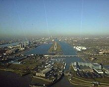
Water transport
River Thames
"River bus" services on the River Thames
The River Thames is navigable to ocean-going vessels as far as London Bridge, and to substantial craft well upstream of Greater London. Historically, the river was one of London's main transport arteries. Although this is no longer the case, passenger services have seen something of a revival since the creation in 1999 of London River Services, an arm of Transport for London. LRS now regulates and promotes a small-scale network of river bus commuter services and a large number of leisure cruises operating on the river. Boats are owned and operated by a number of private companies, and LRS manages five of central London's 22 piers.
Canals
A "water bus" on the Regent's Canal
London also has several canals, including the Regent's Canal, which links the Thames to the Grand Union Canal and thus to the waterway network across much of England. These canals were originally built in the Industrial Revolution for the transport of coal, raw materials and foods. Although they are no longer used to carry goods, they are popular with private narrowboat users and leisure cruisers, and a regular "water bus" service operates along the Regent's Canal during the summer months.
Cargo
Some bulk cargoes are carried on the Thames, and the Mayor of London wishes to increase this use. London's port used to be the country's busiest when it was located in Central London and east London's Docklands. Since the 1960s, containerisation has led to almost all of the port's activities moving further downstream and the ceasing of port-related activity at the extensive network of docks (which were built in the 19th and early 20th centuries). A purpose-built container port at Tilbury in Essex, around ten kilometres outside the Greater London boundary, is today the busiest part of the port, though activity remains along stretches of the Thames, mainly downstream of the Thames Barrier. Fifty riverside wharfs have been safeguarded from development in Greater London. Today the port is the UK's second largest by cargo handled (53 million tonnes in 2008). The Port of London Authority is responsible for most port activities and navigation along the River Thames in London and on the Thames estuary.
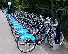
Cycling
A cycle docking station
Cycling in London has enjoyed a renaissance, particularly since the turn of the millennium. Cyclists find that they enjoy a much cheaper, and often quicker, way around town than those travelling by public transport or car.
Over one million Londoners own bicycles but as of 2008 only around 2 per cent of all journeys in London are made by bike: this compares poorly to other major European cities such as Berlin (5 per cent), Munich (12 per cent), and Amsterdam (28 per cent) and Copenhagen (36 per cent). Nevertheless this is an 83 per cent increase compared to that in 2000. There are currently an estimated 480,000 cycle journeys each day in the capital.
The Barclays Cycle Hire scheme, launched 30 July 2010, aims to provide 6,000 bicycles for rental. Bikes are available at a number of docking stations in central London.
(source:wikipedia)